")
")
METHODOLOGICAL APPROACH FOR VINEYARD INVENTORY AND MANAGEMENT
2002-2005
Research and Technological Development Project, co-funded by the European Commission with the contract number EVG1-CT-2002-00075, under the 5th Framework Program, sub-program "Energy, Environment and Sustainable Development".
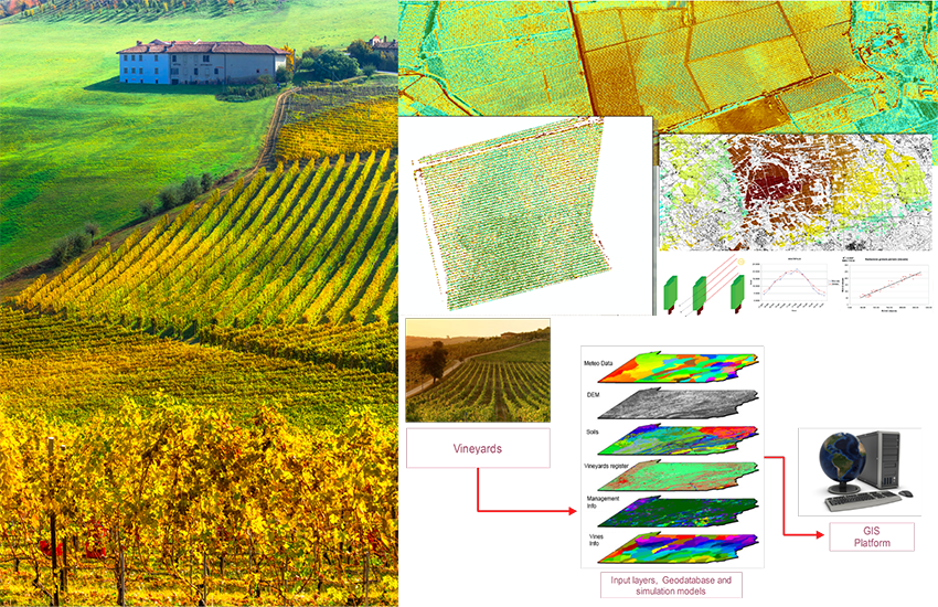
The "Bacchus" project concerned the improvement of the methodologies available for the localization and characterization of the vineyards, through high-resolution remote sensing data and spatial analysis techniques. The aim of the project was to provide Consortia, farmers and wine producers with an integrated and complete system to meet their information needs on vineyard conditions, mainly based on the use of satellite and aerial images, GIS (Information Systems Geographic) and modern software solutions.
During the project we have developed a methodology to perform the inventory of the wine-growing areas and the single vineyard management. This methodology has been tested on various pilot systems with the aim of supporting the end user in a series of activities:
- updating of the regional and local statistics (for the analysis of the Controlled Origin areas (DOC and DOGC), the evaluation of existing trends and / or the study of the variability between vineyards and within the individual vineyard);
- management of the country works and short, medium and long-term interventions (from the preliminary study of the vocational nature of the territory, during the planting phase, up to the planning of the harvest);
- evaluation and monitoring of the vineyards, providing the growth rate of the vine (quantity of biomass), phenological phases (date) and the forecast of grape production (quantity and quality).
Bacchus partners have dealt with all these problems concerning the management of the vineyard, studying and proposing specific and original solutions by integrating new methodologies and techniques into innovative and effective tools. In particular, a new methodological approach has been developed for the implementation of specific tools for:
- updating of the vineyards register by means of remote sensing images;
- precision agriculture applications for the evaluation of vines growth and production estimation, using specific agrometeorological modeling and agrometeorological monitoring stations;
- the management of the vineyards and the evaluation of production scenarios through the integration of traditional databases, GIS spatial analysis tools and remote sensing techniques.